Introduction
Galileo’s High Accuracy Service (HAS) is a key innovation within the landscape of Global Navigation Satellite Systems (GNSS). Galileo, the GNSS constellation developed by the European Union, has been known for its focus on high precision and safety since its inception. With the introduction of HAS, Galileo strengthens its leadership by providing enhanced accuracy—down to the decimetric level—without the need for paid subscriptions or complex additional infrastructures. This article delves into the technical workings of HAS, its benefits, and how it is transforming sectors such as surveying, geographic information systems (GIS), autonomous vehicles, and precision agriculture.
1. What is the High Accuracy Service (HAS)?
The High Accuracy Service (HAS) is a precision service offered through the Galileo constellation. Its primary objective is to provide corrections to GNSS signals, enabling receivers to achieve decimetric accuracy, which is critical for applications requiring a high degree of precision.
History
Galileo’s High Accuracy Service (HAS) is a relatively recent addition to the GNSS ecosystem. Its development was driven by the growing demand for sub-meter positioning accuracy in applications like precision agriculture, autonomous vehicles, and advanced surveying. The concept of HAS began to take shape in the early 2010s as part of the European Union’s vision to make Galileo a more competitive constellation compared to other global GNSS systems. After years of testing and technical improvements, the HAS service was officially launched on January 24, 2023, with the capability to provide real-time corrections to users worldwide. This launch marked a significant milestone in Galileo’s evolution, solidifying its position as a leading provider of high-precision services and expanding opportunities for advanced applications that rely on accurate and reliable positioning.
How the HAS Service Works
HAS utilizes precise corrections to both satellite orbital parameters and clock errors, which are transmitted to users directly from Galileo satellites via signals in the E6-B band. This type of correction is known as Precise Point Positioning (PPP), an advanced method of positioning that, unlike traditional solutions based on reference station networks (RTK), does not require local ground stations to enhance accuracy.
Technical Components of HAS
- Orbit-Clock Corrections: These corrections include precise data on satellite orbital positions and clock errors, which are among the most significant factors affecting standard positioning errors.
- Ionospheric and Tropospheric Models: To improve signal accuracy, HAS also integrates models that compensate for atmospheric effects on GNSS signals.
- Satellite Transmission: Corrections are transmitted directly from satellites via the E6-B band, providing global coverage without the need for additional ground infrastructure.
Differences from Other GNSS Systems
While other high-precision services, such as RTK, require a dense network of base stations to transmit differential corrections locally, Galileo’s HAS offers real-time corrections directly from satellites, enabling global coverage without relying on ground networks. This not only reduces costs but also increases accessibility in remote or poorly connected areas.
Galileo HAS Roadmap:
Phased Implementation The implementation of the Galileo High Accuracy Service (HAS) follows a phased approach, divided into three stages, ensuring the progressive development and maturity of the service.
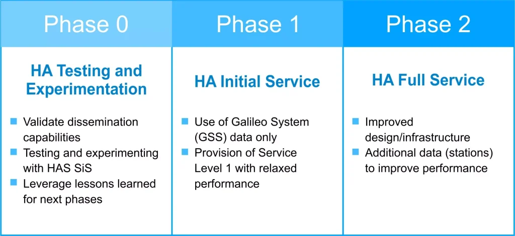
Phase 0 (2020-2022): Testing and Experimentation
The activities of Phase 0 took place between 2020 and 2022, prior to the official declaration of the Galileo HAS Initial Service. During this period, a series of tests focused on specific aspects of the Galileo HAS service were conducted. These tests involved various internal and external program stakeholders, who had the opportunity to experiment with the HAS signal.
External participants provided valuable feedback, which was used to refine the final definition of the service. This process allowed for significant adjustments to be made, ensuring that the service implementation met the expectations and needs of end-users.
Phase 1: Initial Service Declaration
With the declaration of the Galileo HAS Initial Service, Phase 1 was initiated. In this stage, the Galileo HAS Level 1 Service (SL1) was enabled, albeit with reduced coverage and performance compared to the objectives set for Full Service. This limitation is due to the current Galileo infrastructure, such as the Galileo Sensor Stations (GSS) network.
An important aspect to consider is that in this phase, some products anticipated for the Full Level 1 Service (SL1), such as phase biases, are not yet available. Nevertheless, the service already provides a considerable improvement in accuracy and is capable of supporting several high-precision applications, though not at its maximum capacity.
Phase 2: Evolution Towards Full Operational Capability
Phase 2 will represent the evolution of the service towards Full Operational Capability (FOC), at which point Galileo HAS will fully meet the performance objectives set for Service Level 1 (SL1), as described in the table below. Additionally, in this phase, Service Level 2 (SL2) of Galileo HAS will be introduced, offering a higher level of accuracy and reliability, enabled by a more robust and expanded infrastructure.
This phased approach allows Galileo HAS to evolve in a controlled manner, progressively improving its coverage, accuracy, and capability to meet the growing demands of advanced applications such as surveying, autonomous systems, and precision agriculture.
| Performance | Service Level 1 (SL1) | Service Level 2 (SL2) |
| Coverage | Global | European Coverage Area (ECA) |
| Corrections | Orbit, clock, biases (code and phase) | Orbit, clock, biases (code and phase) + atmospheric corrections |
| Format | Open format similar to Compact- CSSR | |
| Dissemination | Galileo E6B using 448 bits per satellite per second / terrestrial (internet) | |
| Constellations | Galileo and GPS | |
| Corrected Frequencies | Galileo E1/E5a/E5b/E6/E5 AltBOC GPS L1/L5/L2C | |
| Horizontal Accuracy (95%) | <20cm | |
| Vertical Accuracy (95%) | <40cm | |
| Convergence Time | <300s | <100s |
| Availability | 99% | |
| User HelpDesk | 24/7 | |
2. Benefits of HAS in High-Precision Applications
The Galileo HAS service has been designed for applications that require extremely high levels of accuracy and reliability, where even a small positioning error could have critical consequences. Below are the specific benefits that HAS brings to different sectors.
2.1 Surveying
Surveying is a field where positioning accuracy is absolutely essential. Modern measurement tools rely on GNSS to perform fast and accurate surveys. With Galileo HAS, centimeter or decimeter-level accuracy can be achieved without the need for costly infrastructure, such as RTK base stations.
Advantages:
• Increased Efficiency: HAS enables faster surveys without compromising accuracy, as there is no need to set up reference stations.
• Global Coverage: Surveyors can operate in remote areas where RTK base stations are not available.
• Cost Reduction: Fewer equipment and infrastructure requirements reduce operational costs while providing sufficient accuracy for engineering, urban planning, and construction projects.
2.2 Geographic Information Systems (GIS)
Geographic Information Systems (GIS) are essential for managing spatial data in fields such as urban planning, natural resource management, and environmental monitoring. The accuracy provided by HAS allows for the creation of extremely precise geospatial maps and models.
Advantages:
• Precise Geospatial Data: Improving the accuracy of GIS layers enables more reliable and detailed decisions based on this data.
• Mobile Applications: Mobile devices or drones equipped with GNSS receivers supporting HAS can capture geospatial data with higher accuracy without relying on connections to base stations.
2.3 Autonomous Systems
Autonomous vehicles, both aerial and terrestrial, rely on precise and real-time positioning to navigate safely and efficiently. In this context, Galileo HAS becomes a key enabler, ensuring that vehicles can calculate their location with decimeter-level accuracy, essential for avoiding obstacles and executing complex maneuvers.
Advantages:
• Precise Navigation: Decimeter-level accuracy allows autonomous vehicles to operate in dense environments, such as urban areas or busy roads, minimizing the risk of accidents.
• Cost Reduction: The elimination of the need for additional infrastructure to provide corrections improves the accessibility of autonomous solutions across more industries.
2.4 Precision Agriculture
Precision agriculture is one of the fields most benefitted by advances in GNSS technology. With HAS, farmers can manage their lands with superior accuracy, optimizing resource usage and improving productivity.
Advantages:
• Accurate Planting and Fertilization: HAS allows agricultural machinery to operate with decimeter-level precision, ensuring optimal planting and fertilizer application.
• Real-Time Crop Monitoring: Drones and ground vehicles equipped with GNSS can provide detailed crop maps and data, enabling farmers to make more informed, real-time decisions.
3. Challenges and Future Opportunities
Despite the significant advancements represented by HAS, there are challenges that could limit its initial adoption. The need for receivers compatible with the HAS signal on the E6 band is one of these challenges, although many GNSS manufacturers are already working to offer this capability in their products. Additionally, the latency of PPP corrections remains an aspect that could affect some applications, although technological advancements continue to reduce these times.
However, the opportunities are vast. The adoption of HAS in sectors such as autonomous transportation, fleet management, smart agriculture, and critical infrastructure can transform how these industries operate, increasing efficiency and reducing costs.
Final Thoughts
Galileo’s High Accuracy Service (HAS) represents a milestone in the development of high-precision GNSS technologies. Its ability to provide real-time corrections and decimeter-level accuracy without additional ground infrastructure makes it a crucial tool for sectors such as surveying, GIS, autonomous vehicles, and precision agriculture. As it becomes more widely adopted and developed, Galileo HAS has the potential to transform multiple industries, ushering in a new era of precision in critical applications.
In this context, METTATEC’s R&D department is currently experimenting with and implementing the integration of the HAS service into our X5 GNSS receiver models, allowing users to benefit from this new technology with enhanced global coverage and significantly reduced convergence times.
References:
• European Global Navigation Satellite Systems Agency (GSA), “Galileo High Accuracy Service (HAS): Technical Overview and Applications,” 2023.
• European Space Agency (ESA), “Galileo GNSS and High Accuracy Service – PPP Innovations,” 2023. • Rizos, C., & Grejner-Brzezinska, D., “Precise Positioning with GNSS: From Research to Real-Time Applications,” Journal of Navigation, 2023.